
search
Amsterdam districts map
Map of Amsterdam showing districts. Amsterdam districts map (Netherlands) to print. Amsterdam districts map (Netherlands) to download. Amsterdam has seven districts (not to be confused with buurten – neighbourhoods in Amsterdam) are Amsterdam Centre, West, Oost, Noord, Zuid, Nieuw-West and Zuidoost as its shown in Amsterdam districts map. Which district you live in will determine which City Office (stadsloket) you need to visit for official procedures such as registration and permits. Districts also organise refuse collection and much more.
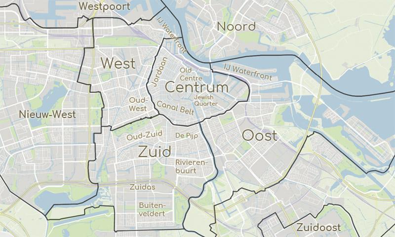
The Centrum district as its mentioned in Amsterdam districts map, with 86,851 inhabitants (2018) is divided into smaller neighbourhoods, all with their own characteristics and history. While the district of Oost in Amsterdam consists of new developments built to extend the city from the late 19th century to the present, including the new islands which are still being constructed. Moreover, the district of Zuidoost was created on reclaimed land. Construction of the Bijlmermeer neighbourhood began in the late ’60s and ’70s. This Amsterdam district is home to an extremely diverse mix of nationalities and cultures.
The centre district of Amsterdam is the old city centre, characterised by canals and historic sights as its shown in Amsterdam districts map. It is where most of the cafés, restaurants, theatres and music venues are situated. The district of Nieuw-West in Amsterdam is a suburb built in the mid-20th century, with lots of green spaces, water and modern architecture. The district of Noord was heavily industrialised until the 20th century. The working-class neighbourhoods still exist, but the old yards and sheds are now hotspots for the media and creative industries.